Light National Demand to Continue Another 8-Days but Then Colder Weather Arrives Nov 12-17
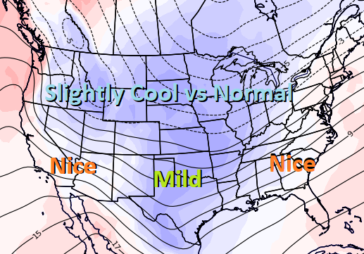
November 4, 2022: Both forecast light to very light national demand the next 8-days as an unseasonably strong and warm ridge rules most of the eastern half of the US with comfortable highs of 60s to 80s, including highs near 70°F across major Northeast cities. Where the pattern is finally cold enough is Nov 12-17 as subfreezing air over the West and Plains releases and spreads eastward across the Ohio Valley and Northeast. However, the weather data is struggling to determine exactly how much subfreezing air will ultimately spread across the Great Lakes and Ohio Valley and where the GFS remains more aggressive with it, leading to below normal temperature over much of the US Nov 12-17. The EC favors the warm ridge over the East being more effective in blocking cold air over the Midwest from advancing eastward but still rather chilly in the overnight run. But what could matter more than just how much cold air arrives over the US Nov 12-17 is what the weather data shows Nov 18-24 and if there will be reinforcing cold shots to keep a cold enough US pattern in place to satisfy. Yesterday’s longer-range EC forecast favored bouts of cold air into the northern US for the 2nd half of November but wasn’t as cold as needed to be considered bullish. Essentially, the weather data isn’t convincing on whether enough cold air will hold over the US Nov 18-24 to impress, and where the failure to do so could lead to disappointment. As such, if the weekend weather data shows cold holding across the northern US Nov 18-22, it’s likely to be applauded at the Sunday reopen. However, if the weather data shows a warm/bearish pattern returning Nov 18-22, this will likely lead to disappointment/selling. Clearly, a dangerous weekend to hold depending on weekend weather trends.
