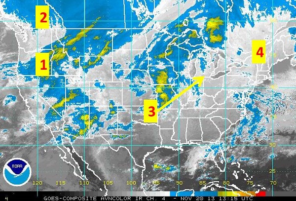
Wednesday Morning Satellite Analysis
This mornings satellite analysis shows nicely the very cold air over southwestern Canada as it readies for its advance into the US. Of interest in the image is:
1) A weather system and associated cold front moving through the Pacific NW into the Intermountain West.
2) Bitter cold air over southwestern Canada. When you click on the loop of the satellite you will notice the blue colors over this region don’t move like the clouds do. The reason is the satellite is sensing temperature and it typically doesn’t expect to find those cold of temperatures until much higher up off the ground where cloud cover is observed. The satellite thus thinks its cloud cover and is being tricked by how cold the air is. http://www.ssd.noaa.gov/goes/comp/ceus/flash-avn.html
3) Mild conditions out ahead of the cold air in the Plains will push eastward over the next 2 days.
4) Cold northerly flow over the Northeast continues to lead to below normal temperatures this morning but will warm nicely the next few days ahead of the bitter cold for the weekend. You can tell this is fairly cold air by the clearing off the Maine coast that eventually turns into cloud streets offshore, much like that observed with Lake Effect snows where cold air flows over the warmer temperatures and leads to instability and clouds.