Wednesday’s Free Forecast
Wednesday’s Free Forecast Subscribe To NatGasWeather.com
|
Weather Forecast Summary (May 14th– May 20th): A strong slow moving spring storm continues tracking across the central US with heavy rains, thunderstorms, and even a few late season snowflakes. This has brought cooler than normal conditions across the central US as highs struggle to reach the 50s and 60s. Due to the slow movement of the weather system, the eastern US will see pleasant temperatures for one more day before the cold front arrives Thursday and reinforcing blasts follow into early next week. In addition, portions of high population California will again warm into the mid 90s and drive strong early season demand for cooling. Additional weather systems will follow late next week and lead to a sloppy pattern, but they will fail to tap cool Canadian air and allow temperatures to moderate to near normal as areas of showers and thunderstorms continue over many regions as active spring weather plays on.
8-14 Day Outlook (May 21-27th): The active and cool pattern that has been relentless this winter season will finally lose its grip during the last week of May. High pressure will strengthen over the western US and Plains as the outlook progresses while temperatures warm to near or above normal over most regions. This will lead to near perfect build weather although the heat will be intensifying as June approaches. Trend: Neutral
Weather Discussion & Confidence: The current trough moving through the US and the reinforcing cool blasts to follow will likely be the last significant cold Canadian outbreak of the winter/spring season. There will be numerous additional weather systems to track through the US over the coming weeks but they won’t effectively tap any decent cold Canadian air. This sets the stage for a big transition to take place, and it looks like it will do it late this month as we have been expecting. There are many ways the pattern can unfold and it’s clear to us it’s going to be to the hotter/milder side depending on how high pressure builds out of the West during the last week of May. The weather models will struggle and expect national forecasts to be all over the place and underplay the potential for heat as June approaches. We think the heat could expand rapidly over the central US and potentially further east, which could bring a surge in cooling demand as portions of the US warm into the 90s and 100s. Confidence: MODERATE – HIGH
Heating Demand Next 7 Days (Compared to normal): MODERATE…becoming LOW.. Much cooler conditions have set up over the central US driving overnight heating demand as lows drop into the 30s and 40s. High population regions of California will again see unseasonably hot temperatures with highs rising into the mid 90s and cooling demand remaining strong. However, the East is still very pleasant and will counter with lower demand than normal until the front passes through Thursday. Late next week the trough will weaken and demand will slacken considerably leading to good build weather.
Weather Threat: MODERATE – LOW
Market Effect: The nat gas markets continued the steady slide Tuesday. After this week, weather conditions will be more favorable building supplies as near normal temperatures set up. There will still be a few cool blasts late next week, but they will fail to tap any meaningful cool Canadian air. The ridge over the Southwest will expand at times into the Plains and Great Basin over the next two week but will never be able to really strengthen, for now. But as the last week of May plays out, the ridge will begin to flex its muscle and start expanding into the central US. This will lead to increasing heat as June approaches and sets the stage for what we expect to be a critical point in the markets. If the heat does strengthen into June, which we think could very well happen, there will likely be many regions rapidly warming into the 90s and 100s. The question is really will the heat cover enough of the US to bring a big enough surge in cooling demand to kill the builds? There is a decent chance it will but it’s not a certainty at this point. So the markets will be held hostage to what we think is going to be a very critical June. Until then, the weather patterns continue to look favorable with temperatures warming to near or above normal as the relentless winter madness finally comes to an end over the northern US. This should provide plenty of reason for the bears to remain in charge. But at the first sign of impending widespread heat, this could all change. And the sooner it happens in June, the more likely prices will find support and the higher the market will go.
Selected Weather Images –

8-14 Day Outlook: The models are all over the place with the pattern going into the last week of May. The latest forecasts have flip-flopped back to a little bit cooler conditions. We won’t bite and will wait until they come back around to the image that we are showing here with above normal conditions gradually setting up as the last week of May unfolds.

Wednesday Weather: The slow moving weather system over the central US continues to bring heavy rains, thunderstorms, and much cooler than normal temperatures. The eastern US will have one more mild day before the cold front moves through Thursday. The west continues to warm while California will again see near record heat as highs again warm into the mid 90s with strong early season cooling demand.
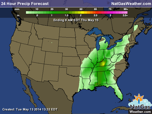
Another round of decent rains over the east-central US as the slow moving cold front trudges on. Slow moving storms lead to heavy rain amounts. The rain will shift to the east coast Thursday.
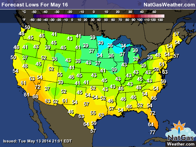
Much of the US will see chilly overnight lows with temperatures dropping into the 30s and 40s both Thursday and Friday driving stronger than normal heating demand. The image shows morning lows Friday which is nearly identical to Thursday morning with just a bit more of the east under the cooler trough.
That is some serious heat building in the West during the last week of May if the forecast models unfold as we expect they will. The pattern is sloppy and there is still plenty of flip-flopping to come. But the pattern is going to be clearly much warmer than it has been and if the heat builds like it shows in this image, the West will be cooking and the heat will be ready to push into the central US.
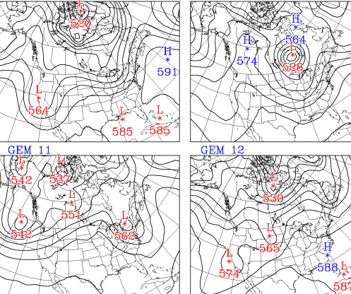
This is the weather pattern around May 27th according to the GFS ensembles. Each scenario is different but they all show milder conditions setting up. We prefer the way the pattern plays out in some flavor of the images on the left, particularly lower left as high pressure kicks out of the West and into the central US. There are still a few that bring a few cooler weather systems across the northern US, such as the upper left, but we are not convinced the models know how to handle this upcoming transition.