Z_forcast_march17
US Natural Gas & Heating Weather Forecast
Warming Today & Tuesday Followed By Northern US Cool Blast Mid Week
Below Normal Temperatures Over Highest Use Northern States All Next Week
Currently Updating Forecast…
Monday 10:00 pm EST
Mid Day Pattern Update: The latest morning data continues to stream in and so far the models are giving us exactly what we would expect; A very stormy pattern with cold air getting hung up over the northern US through around March 26th and then anything from warm surges, cold outbreaks, and strong winter/spring like storms rolling across the country to close out the month. Where and how intense the coming cold will be is going to lead to frustration for big market players as they get whip-sawed on differing national forecasts to come in this extra sloppy pattern. The latest operational 12z GFS run did favor a bit longer ridge into the Northeast to close the month, which the market players may hear as a milder trend. But that’s a long ways out and the coming cold that sets up this weekend into next week should give the markets plenty to watch for the time being as what comes after is likely to change anyways. We are convinced this unsettled pattern will continue into April with many opportunities for cold outbreaks to push into the northern US. While the southern US and Plains warm at times, there will be plenty of cold intrusions deep into the US that will prevent any regions from seeing a prolonged period of much warmer than normal temperatures.
Forecast Summary: (March 17th – March 23rd) The biggest changes to the coming weather since the markets closed last week are a slightly less impressive cold/cool outbreak later this week for the northern US, but more importantly,the models have really backed off on what was to be another big warm up beginning March 22-25th. It is now likely to play out much colder as reinforcing Canadian air into the highest use states should set up. Until then, a winter storm will track out of the Mid-Atlantic and Southeast today with a cold morning to start the week over the Northeast. However, a decent warm up will follow into Tuesday before yet another weather system tracks across the northern US Wednesday and Thursday with a fresh cool blast and some light precipitation. It is not an exceptionally cold blast but will keep may regions near or slightly colder than normal. Another quick warm up should transpire Friday into Saturday before a more impressive cold front sweeps through the northern and eastern US and lasts a solid 5-7 days with colder than normal temperatures over the highest use states of the Midwest and Northeast, leading to strong demand. As we have been saying for quite some time, this is a very active and overall cooler than normal pattern and there is nothing to suggest it will change anytime soon.
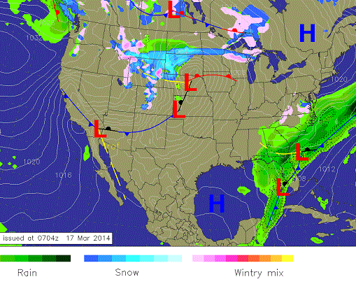
Monday Evening Weather: The storm over the Southeast and Mid-Atlantic will gradually push into the Atlantic with moderate showers continuing. A fresh weather system will slowly push out of the northern Plains but not before a brief period of milder conditions race out ahead of it.
8 -14 Day Outlook
8-14 Day Outlook Summary: (March 23rd -30th) An active pattern will unfold over the outlook with numerous Spring like storms rolling through the country. Much colder than normal conditions will become anchored over the northern US, including the highest use nat gas state of the Midwest and Northeast. Milder and stormy conditions are possible late in the outlook over much of the country.
8-14 Day Outlook: Much colder than normal conditions are expected to set up over the Midwest and eastern US as several Canadian cold fronts sweep through with strong winter storms as well. The Plains and western US will see near or above normal conditions under high pressure.
8-14 Day Outlook Details: (March 23rd – March 30th): An active pattern will start the outlook as reinforcing cold blasts sweep into the northern and eastern US while the southern US and Plains remain relatively mild. Colder than normal conditions should become anchored over the highest use nat gas and heating states of the northern US for the first several days. But what comes after March 26th is where it gets really trick. There should be some sort of very strong temperature gradient across the northern US around this time but exactly where is a problematic and there will be huge swings in national forecasts to come as the models struggle to find direction on where this sharp cold gradient sets up. However it plays out, it should be very exciting as it could lead to a massive US cyclone around March 28th that would surge warm conditions out into the Midwest and Northeast and then follow with several days of colder than normal temperatures. So on and on it goes. Warming over the southern Plains at times with many more cold blasts to come for the Midwest and eastern US into the foreseeable future. This will consistently bring enough cold days within any given draw week to keep demand near or greater than normal. This will also keep supplies below 1.0 Tcf for many weeks to come and maybe, just maybe, winter has one more surprise or two for the markets. We like the odds.
Natural Gas & Heating Demand (compared to normal): MODERATE – HIGH.
Weather Market Threat: Days 1-15: MODERATE – HIGH.
Market Effect: (For March 18th) – The nat gas and heating markets found some buyers Monday and made it a recently rare two day win streak when factoring in Monday’s meager gains. It very well could just be some short term profit taking from the bears with more downside to come. But then again, storage and weather conditions are very supportive of the market and there is plenty of reasons for higher prices, especially as the colder than normal pattern plays out into April for the highest use nat gas states of the northern US. There is a lot of uncertainty for the market to come as weather models will struggle for the foreseeable future in a very complex and stormy pattern. This will lead to wildly varying forecasts from national vendors as well as frustration for big market players trying to plan ahead. So again, we will sit tight and see if the bulls can gradually get momentum over the coming week as the realization that the spring injection season will be WAY behind schedule with the potential for numerous cold or cooler than normal outbreaks to come. Eventually the market will again realize the importance of each of these cold blasts and the damage they are doing in keeping supplies well below the 5 year average every passing week. That’s the way at least we see it. If you believe the nat gas and heating markets moved solely on coming weather when considering current storage levels, then you would believe prices should be supported due to relentless onslaught of chilly weather over the northern US.
The nat gas and heating markets consolidated Friday after selling off Thursday post storage report. The bears clearly have momentum and there is no reason why they won’t try to push prices another leg lower after some potential profit taking. But we believe the market has gotten ahead of itself as many are focused on the calendar and not weather conditions and supplies. The cold blast coming after the brief early week warm up could have played out a bit more impressively if colder air was able to push a bit deeper into the central US. It looks to play out cooler than normal, but not exceptionally so. However, the market bought into a decent warm surge coming March 22-25th which now doesn’t look like much at all. We have been saying this was a very stormy and active pattern coming and there was lots of ways it can play out as the forecast models struggle with lots of chaos in the atmosphere. And true to form, the weekend models brought in a flip-flop to colder conditions than normal instead, pushing the warm up until after the 26th for the Midwest and Northeast. The late March forecasts will hinge on where a very sharp temperature gradient sets up over the northern US or southern Canada thereafter. Feel free to again bite to the warm side, but we know every time it gets closer the forecast data starts backing off. And so the colder than normal pattern for the highest use states of the northern US will hold in place into April as numerous winter storms track across the country with each one being fairly effective in drawing in colder or cooler Canadian air. We have to maintain the view that the longer this cold pattern drags on into April, the more nervous the bears will become as they realize supplies aren’t increasing at rates necessary to support what the market has been hyping, especially with supplies below 1.0 Tcf. Prices will eventually again be supported as the market realizes they placed too much faith supplies would easily be replenished. It just might take a little while longer for the markets to realize it.
Selected Weather Images:
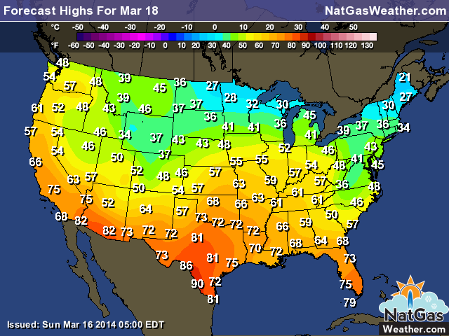
Temperatures will quickly rebound early this week as highs into the 50s and 60s push into the lower Midwest with very pleasant conditions over the southern US and central Plains. Cooler temps will follow later this week as a period of colder conditions set up.
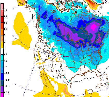
fresh cold blast is becoming likely from March 23-25th as it pushes fairly deep into the eastern US. If this pattern were to play out, temperatures 15-25F colder than normal would set up over the highest use states of the Midwest and Northeast and lead to a much higher than normal nat gas demand. The image shows temps March 25th a few thousand feet off the ground in Celsius. Purples indicate very cold air.
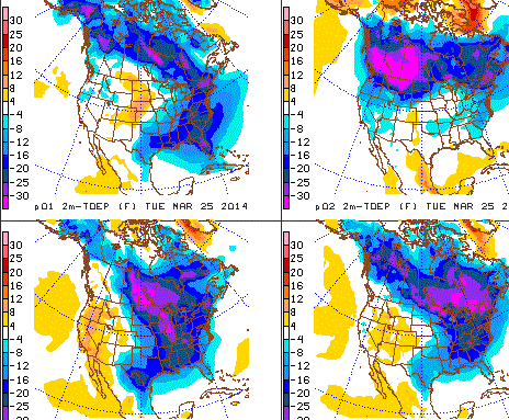
The models led may astray showing a warm up would come March 22nd-25th and now the forecast models have flip-flopped back to a colder solution. The image shows ways the pattern can play out March 25th and they all are showing colder than normal temperatures over the Midwest and eastern US with some areas seeing conditions 15-25F colder than normal. A
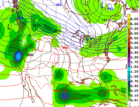
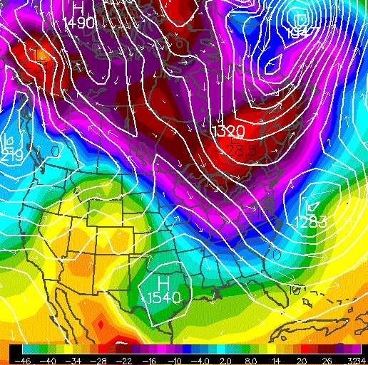
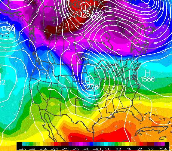
Where it gets really tricky is after the next period of cold ending March 26th. There should be some sort of very strong temperature gradient across the northern US (see tight packing of dashed blue lines). Where is a big problem. There will be huge swings in national forecasts to come as the models struggle to find direction on where cold or warm sets up. However it plays out, it should be very exciting as it could lead to a massive US cyclone. See next image. The flow has to buckle at some point.
Around March 27th another warm surge will be attempted as the pattern favors a strong storm over the central US. We show this image not because we think it will play out exactly like this but rather to show the pattern favors strong winter storms with the potential for brief warm surges followed by cold outbreaks. As long as there is sufficient cold air near the Canadian border, then don’t expect a big warm up to last more than a couple days.