z_Feb21st
US Natural Gas & Heating Weather Forecast
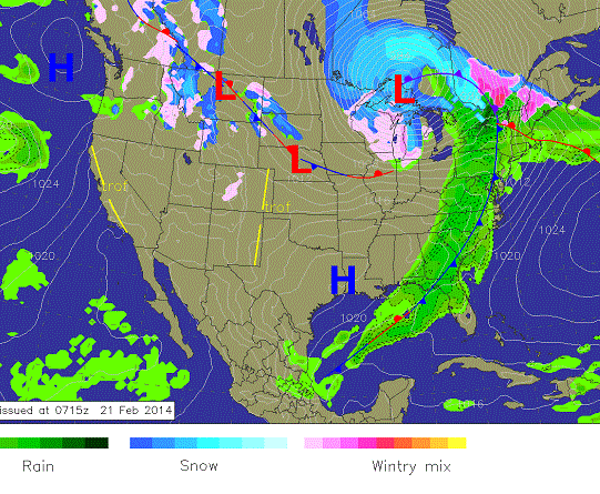
Friday Weather: A massive springlike storm will be tracking through the US with showers and thunderstorms ahead of the cold front and heavy snowfall into the Midwest. Note the strong packing of isobars over the Great Lakes. When the isobar lines are packed tight, very strong winds develop. The “big” warm up is almost already over as cold air will be filtering in on the backside of the storm.
Forecast Summary: (Feb 21st – 27th) A strong springlike storm continues to track into the eastern US with a line of showers and strong thunderstorms along the cold front and heavy snowfall over the Great Lakes. This is a massive storm in terms of the number of regions it encompasses, as it stretches from Canada to the Gulf of Mexico. While the initial cold blast that follows in it’s wake won’t be super impressive, it will open the door for much colder ones to come. Saturday will be relatively quiet and temperate before a return to the deep freeze begins to unfold. A very strong Canadian cold front will sweep across the northern Plains and Midwest Sunday, ushering in temperatures well blow zero and brisk winds. A dangerously cold and more impressive Arctic is expected to follow Tuesday through Thursday for the highest use states of the northern US. This still looks like the real deal as far as extreme and potentially record breaking cold, which will lead to very high nat gas and heating demand. Of concern are temperatures dropping to -25°F across the Great Lakes region and well below zero for portions of the Northeast. In addition, single digits and teens are expected to advance deep into the Mid-Atlantic and portions of the Southeast, exacerbating demand. Wherever the Arctic front stalls over the southeastern US late next week, a wintry mess of precipitation is likely to set up. We expect the cold to become anchored over the US through March 3rd before a very exciting weather pattern sets up.
8 -14 Day Outlook
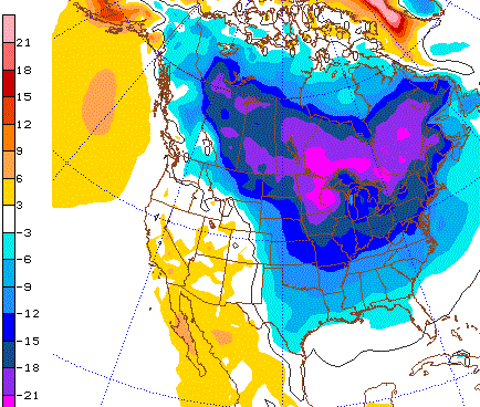
8-14 Day Outlook Summary: (Feb 28th – March 6th) A dangerously cold Arctic blast will be anchored over the highest use nat gas and heating states of the northern US to start the outlook period. These very cold temperatures will hold through March 4th with the Midwest and Northeast experiencing temperatures 10-25°F colder than normal, with less extreme, but still unseasonably cold conditions pushing deep into the Southeast. High pressure over much of the US will lead to mild and dry conditions with Pacific storms arriving late in the outlook.
8-14 Day Outlook Details: (Feb 28th – March 6th): An impressive potentially record setting Arctic blast will be impacting much of the central and eastern US to start the outlook period. Brutally cold conditions with temperatures well below zero are expected over the Midwest and portions of the Northeast for at least the first 5 days of the outlook. There is no doubt very high nat gas demand will occur over the highest use states of the northern US. What is still in question is exactly how far the cold will be able to advance into the Southeast. Battle lines will be drawn in the vicinity of Tennessee/N. Carolina as a very sharp transition to extremely cold temperatures will occur just to the north with much milder above freezing conditions to the south. It will be a slugfest all week to see how far the cold can advance into the southern US, making forecasting temperatures in this region tricky. We still expect the cold to hold through March 3rd before a very exciting weather pattern sets up to close out the first week of March. We believe this will play out with some very powerful winter storms tracking the nation with a bias toward cold temperatures remaining across the northern US. This March pattern will cause the forecast models to struggle, leading to whipsawing national forecasts and frustration for market players trying to plan ahead.
Natural Gas & Heating Demand: MODERATE Days 1-3. HIGH-VERY HIGH 4-15.
Weather Market Threat: Days 1-15: VERY HIGH Days 1 – 15.
Market Effect: (Feb 21st) – Thursday ended up being a consolidation day for the nat gas markets as they struggled to find direction after the morning weekly storage report. It came in line with expectations as the period brought in a draw of -250 Bcf. After the initial sell off seemingly because the number wasn’t bigger, the market spiked higher before selling to close the day. We believe it is certain very cold air is coming to the northern US for a solid week long period. How far the cold pushes toward the Southeast is really the only thing in question. The cold next week across the northern US is going to bring a very big draw after muted demand this past week. However, the combination of the two will still be bringing reserves to right near 1.0 Tcf by early March. Then there are still another 3 weeks and all of April to endure and it’s very unlikely a prolonged 30-50 day warm up will miraculously appear, especially when the pattern to close out the first week of March looks mighty active with very cold air over the northern US or lurking very close by in southern Canada. Would you want to be short this market going into the weekend with a nasty Arctic blast barreling down, cold looking to hold through the first week of March, and reserves continuing to plummet and distance further from the 5 year minimum? We think not, and believe today could be a very telling day as those short the market could be forced to make a mad rush for the exits.