z-Feb23rd_forecast
US Natural Gas & Heating Weather Forecast
Very Cold Conditions To Impact Northern US All This Week
Forecast Summary: (Feb 23rd – March 1st) A strong cold front will sweep across the northern US today and tonight, bringing another round of strong nat gas and heating demand across the Midwest and Northeast. Light snow showers are expected near the Great lakes and over the northern Plains and Rockies with only minor accumulations expected. The more impressive Arctic blast will push into the US Monday Night, ushering in temperatures of -15-20°F for much of Midwest. However, the extreme cold may not have quite the oomph to push deep into the Northeast, including some high population cities near the coast, although temperatures will still be an impressive 15-25°F colder than normal. With a reinforcing shot of cold to follow for the northern US Thursday, cold temperatures will remain anchored until a weather system coming out of the Plains Saturday and allows a surge of warmer southerly flow into the central US and Mid-Atlantic, forcing the extreme cold over the north to abate. This would bring a couple of days of moderating temperatures and easing nat gas demand. However, on the back side of the low will likely be another reinforcing cold blast that should put the northern US back into a very active pattern that favors cold to very cold temperatures along with the potential for strong winter storms. This has to be viewed as bullish to the markets as reserves continue to deplete.
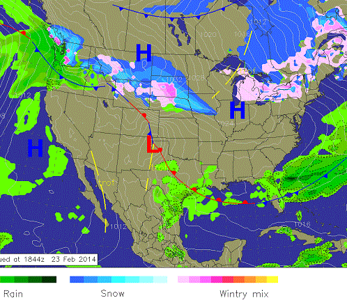
Monday Afternoon Weather: The latest cold blast will be pushing through the northern Plains with some light snowfall. Cold and unstable air near the Great Lakes will lead to some light snow showers. A stalled front will lead to some heavy showers over the Southeast coast while the west basks under winter sun.
8-14 Day Outlook: Cold air will remain over the northern US and at times push into the Southeast. This will lead to temperatures on average being more than 10F colder than normal for the highest use nat gas and heating states of the Midwest and Northeast.
8 -14 Day Outlook
8-14 Day Outlook Summary: (March 2nd – 8th) An exciting weather pattern will set up during the first week of March. Very cold air will be anchored over the highest use nat gas and heating states of the northern US with temperatures averaging more than 10-15°F colder than normal. Strong winter storms will bring opportunities for heavy rain and snow across much of the US.
8-14 Day Outlook Details: (March 2nd – March 8th): Cold air will be anchored over the Midwest and Northeast for much of the outlook period. As one storm exits and leaves cold air in its wake over the northern US on March 2nd, a much stronger winter storm will be winding up over the central US. This will allow a 1-2 day surge of milder air into the Ohio River Valley and Mid-Atlantic before the storm comes barreling through. Heavy rain, thunderstorms, and snowfall will accompany this potentially massive winter storm. Of importance will be the cold air the storm will be tapped on the backside over southern Canada.
This would lead to another several day period of colder than normal conditions over all of the northern US and potentially portions of the central and southeastern US as well. However, the cold air that occurs in the outlook won’t be as impressive as what occurs this coming week, but will still average 10-15°F colder than normal. We do think the pattern will be a sloppy mess by the end of the first week of March with numerous weather systems tracking through trying to drag cold air on the backside into the northern US with each pass. As one exits stage right the next one comes in stage left out of the northern Plains and gives it a go in a very similar fashion. Simply put, there is nothing to say the cold and active pattern over the highest use northern states will end anytime soon.
Natural Gas & Heating Demand: HIGH-VERY HIGH Days 1-9 HIGH Days 10-15.
Weather Market Threat: Days 1-15: VERY HIGH Days 1 – 15.
Market Effect: (Feb 23rd) – We said last week we were very interested to see how the markets would react going into the weekend with an Arctic barreling down, cold looking to hold through the first week of March, and reserves rapidly dropping toward 1.0 Tcf. It wasn’t until a late day fake out that the nat gas markets surged higher to close the day. Will the momentum carry over this week with prices rocketing to fresh highs as those who failed to get out late Friday are going to be too late to the party? We don’t think it’s impossible a full fledged weather market could be unfolding as another 14 days of cold looks to greet the big market players as the week begins. Will this bring a run for the door exit as supplies steadily drop over the coming weeks with no relief in sight? We know this weeks coming draw won’t be huge but we know the next one and likely two will again be well above average and the summation of them should put supplies at or less 1.0 Tcf. If there are another couple of weeks with decent draws coming in March or early April then it seems conceivable we could be dropping toward 800 Bcf, or dare I say even lower. We believe this week could be a very exciting as the big market players digest the realization that colder than normal conditions will remain anchored over the northern US for some time. This surely should support prices and it doesn’t seem impossible prices spike in a late season weather market. Could you really get a more perfect set up?
Selected Weather Images
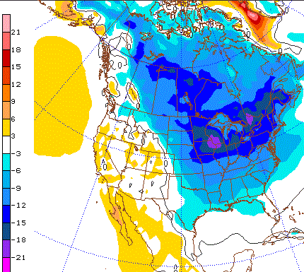
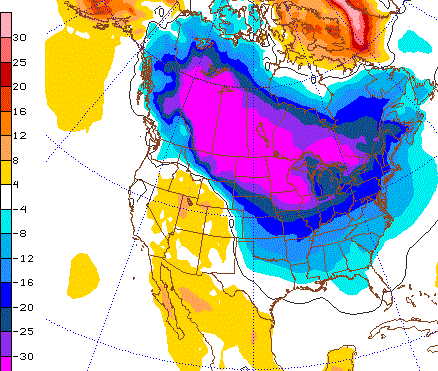
The coldest blast of the coming week should occur Monday night into Tuesday as an Arctic air mass pushes through the Midwest with brutally cold temperatures. It will also be this blast that pushes the furthest into the Southeast as following ones will remain over the northern US. The image shows temperatures in Celsius a few thousand feet off the ground. Dark blues and purples are really cold, Reds to yellows represent extreme cold.
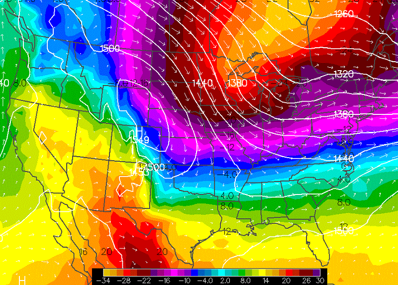
Wednesday morning temperatures are going to be quite cold across all of the northern US as lows drop well below zero over the Midwest and into the portion of the Northeast. Once this cold sets up it will hold through Saturday as reinforcing cold blast tracks across the Great Lakes Thursday.
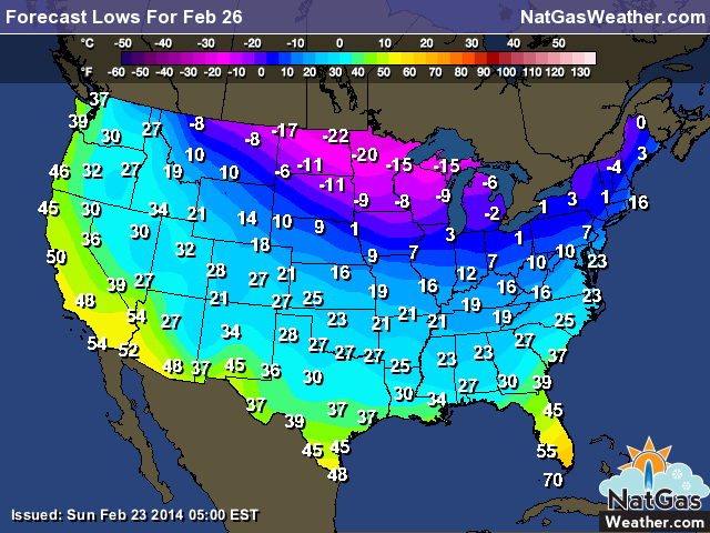
The image shows the temperature anomalies for the coming Friday. We selected it isn’t much different than what it looks like on Tuesday. Once the cold pushes in Monday night and Tuesday, it isn’t going anywhere until the weekend. Extreme cold does stall just short of the Northeast coast, which could save a few higher pop cities from dangerous cold. The Midwest has temp anomalies of more than -35F colder than normal. For them, that is extreme.