Z_foreast_lastone_may11
US Natural Gas & Heating Weather Forecast
Near Normal Conditions Through The Weekend Then A Strong Cold Blast Next Week
Saturday 11:45 am EDT
Forecast Summary: (May 9th-15th) A very sloppy weather pattern has set up over the US this weekend with several disorganized weather systems tracking through leading to areas of showers and thunderstorms over several regions of the country. This had flattened and weakened the ridge of high pressure that led to warm conditions much of the past week. It will still be mild over the southern US and near normal across the north until early next week when a much stronger cool blast arrives. Initially the strong Canadian cold front will push into the north-central US around Tuesday and then gradually push deep into the southern US, especially southeastern US around Thursday. This will lead to much of the central and eastern US experiencing much cooler than normal conditions late next week into the weekend. This will drive some demand for nat gas and limit next weeks build after a decent build this past week. Reinforcing cool blasts follow into the last week of May, but at this point they don’t look like they will be overly impressive, although the weather models will likely trend cooler with time.
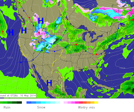
Weekend Weather: Several disorganized weather systems will track across the US, especially over the north with areas of showers and thunderstorms with snowfall into the western mountains. Near normal conditions will set up with mild southern US weather.
8 -14 Day Outlook
8-14 Day Outlook Summary: (May 16th – May 22nd) A fairly strong Spring storm will over the central and eastern US during the first few days of the outlook. This will lead to heavy showers and thunderstorms which will be followed by an impressive cool blast that will push deep into the southeastern US. Temperatures will then moderate to near normal over much of the US at the end of the outlook while active spring weather continues.
8-14 Day Outlook: A strong cool blast over the central and eastern US will lead to temperatures well below normal. Warmer conditions are expected late in the outlook as high pressure builds back in. The western US will be much warmer than normal as the heat builds.
8-14 Day Outlook Details: (May 16th – May 22nd): A strong Spring storm will be over the central and eastern US next week with rounds of showers and severe thunderstorms. We have been saying the models would come around to colder for mid May and they have done just that as temperatures look to drop 10-20F colder than normal over many regions for several days. It is also likely cool conditions will push quite deep into the southeastern US. After the trough exits, temperatures will moderate to near normal even though the pattern remains active. We do caution the models will likely again come around to a few more cooler outbreaks as we push later into May. This will keep enough demand ongoing to prevent any builds from being exceptional, although this week should be fairly big if this past week was able to bring in a +74 Bcf build. We do expect the southern US and Plains to warm at times over the outlook period, especially late, but the core of the significant early season heat will remain over the Southwest. We continue to see the potential for a big pattern change in the offing, but it will take some time to play out to end this cool season madness.
Natural Gas & Heating Demand (compared to normal): LOW…Becoming Moderate Next Week
Weather Market Threat: Days 1-15: MODERATE
Market Effect: (For May 9th): The nat gas markets sold off sharply after the EIA weekly nat gas report came in with a build of +74 Bcf. Seems like a pretty high number considering much of the nation experienced below normal conditions and it came in nearly the same as last week when it was considerably milder. Curious indeed. That doesn’t bode well for next weeks report as conditions will have been much milder and the build should be greater. So maybe over +90-100 Bcf isn’t out of the question. Next weeks cool blast continues to look fairly impressive and should push deep into the southern US with the forecast models again locking in on the colder solutions we have been forecasting. It’s really a couple reinforcing cool blasts that follow into the weekend that could do the damage and keep cooler than normal conditions ongoing, not to mention bringing additional rounds of showers and thunderstorms tracking across the US. Going into the last week of May temperatures will again moderate over the northern US and much of the country as high pressure builds into the southern US and Plains for a decent warm up. However, a few more cool blasts and spring storms will likely be tracking across portions of the northern US at times, which will keep warm conditions regionalized and keep perfect build weather from setting up. That is not to say decent builds won’t occur, just not exceptional to make significant ground on the current supply deficit. Until the pattern becomes more favorable later in the month, any significant sell offs should be considered buying opportunities.
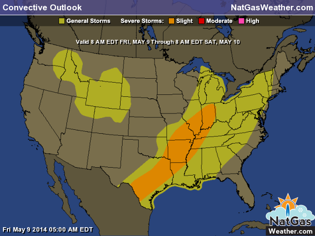
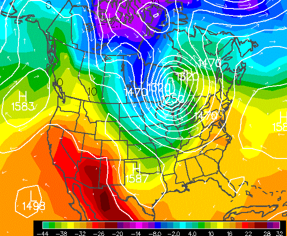
Another round of strong thunderstorms are expected today, espcially in the afternoon and evening as a slow moving spring storm track east. Under a cold trough over the West a few thunderstorms are expected.
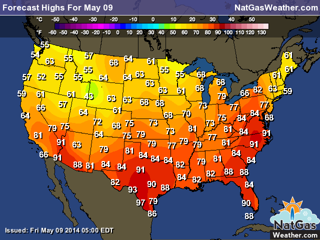
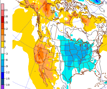
Temperatures will be a bit cooler over much of the central and northern US today as a weather system moves through with moderating temperatures. It will still be fairly warm ahead of the cold front in the East and Texas as highs reach the 80s with a few 90s. Elsewhere temps will generally be in the 60s and 70s.
Additional cool blasts will push into the central and eastern US next week and will likely push fairly deep into the southern US. This will cause the warm conditions over the Plains to retreat back into the Southwest.
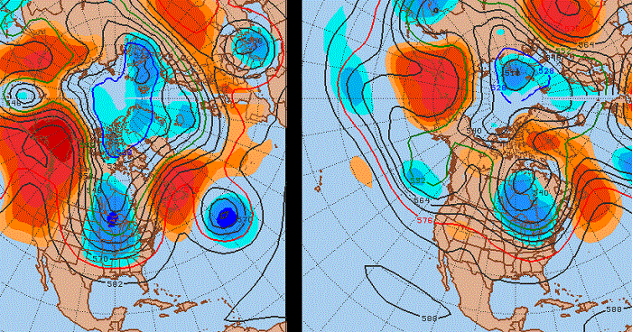
The image shows the EC weather model on the left and the GFS model on the right for the pattern May 16-18th. They have been flip-flopping lately with the EC now being colder and digging the trough deeper into the central and southern US for a more impressive cool down. The GFS has backed off slightly on the Thursday night 00z forecast run. Either way it will be colder than normal but details of by how much still need a little ironing out. Also note how much stronger the EC has the ridge on the West coast.
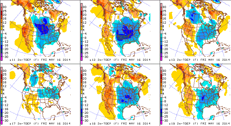
Friday of Next week will have a significant trough over much of the central and eastern. This will lead to much cooler than normal conditions. We expected the models to come around to colder and they have obliged. The image shows potential ways the cold plays out late next week and they all now show fairly cold temperature anomalies. There are still a few outliers, but the trend is certainly colder.
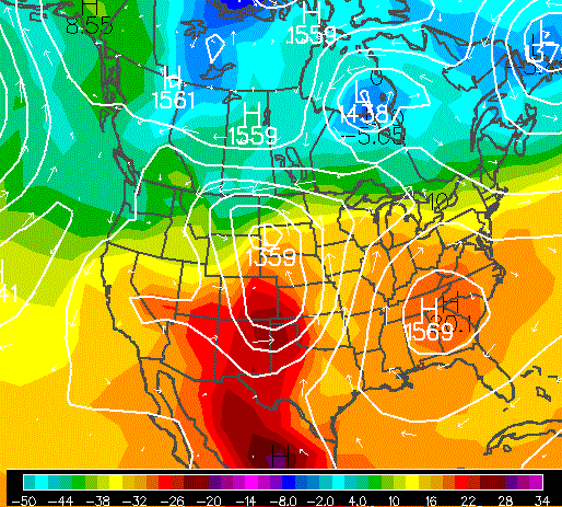
Times they are a changing! This weather map shows temperatures off the surface around May 23rd. It’s a precursor of things to come. Enjoy!